

- 14 Super Fun Things to Do in Dallas with Teens - January 31, 2024
- 13 Really Fun Things to Do in San Antonio with Kids - November 13, 2023
- 16 Most Romantic Getaways in Pennsylvania For Couples - November 8, 2023
The River Walk and the Alamo are top attractions for a reason, but hiking in San Antonio offers a gorgeous escape from the crowds and a different view of central Texas that is well worth exploring.
These San Antonio trails don’t make it onto tourist itineraries nearly as often as some of the city’s other destinations, so we’re letting you in on the natural secrets tucked away not too far from downtown.
With 14 incredible hikes on this list, there’s a little something for everyone so that you can find a trek suitable for any age or ability. Local species, wildflowers, and sweeping vistas are all on the agenda.
Keep reading for need-to-know info on how to get to each spot, trail lengths and difficulties, unmissable lookouts, wildlife to watch out for, and more!
Tips and Advice for Hiking in San Antonio
Trash your trash: People leaving trash, dog poop, and other paraphernalia on trails across the USA is becoming an increasing problem. Leave no trace.
Watch out for wildlife: Some animals might feel or be unsafe near humans. Never startle, disturb, approach, or feed wild animals.
Don’t pocket the past: Help preserve the great American heritage. Leave all artifacts exactly where you find them and report their location to a ranger.
Campfire only in fire ring: When allowed, only have a campfire in fire rings to avoid ground scarring and wildfires.
Know your limits: The reason we include trail info, such as distance and elevation gain, is so that you can plan according to your physical condition. Beyond that, always wear sunscreen, insect repellent, and appropriate clothing/hiking shoes. For instance, these trail-runners have the perfect balance of breathability and terrain grip.
Share your plans: Because some trails are more challenging and far out in nature, it’s always better to let others know where you’ll be.
Drink plenty of water: Last but definitely not least. Pack enough potable water with you. We love this high-quality Camelbak and it fits 70oz of water.
Buy the America The Beautiful Pass: If you plan to visit three national parks within a year, the best value is to buy the America the Beautiful pass. For only $80, you get access to every US national park with this handy national park pass. We highly recommend it! Click here to buy you America the Beautiful pass.
Best San Antonio Hiking Trails
People tend to embark on either big city trips or more nature-centric adventures, but what about the wealth of natural areas that are not too far from urban comforts?
That’s exactly what we’re exploring with this list, and all revolving around one of our favorite cities in the United States–San Antonio!
Easy San Antonio Hikes
Rio Medina Trail


- Length: 12.6 miles | Elevation gain: 459.3 feet | Guide
Located within the Medina River Natural Area, this trail is well-marked, super accessible, and packed with wildlife.
Winding switchbacks and rolling hills make the out-and-back trail challenging enough for intermediate hikers, but the mostly paved roads keep it beginner-friendly as well.
The sections that meander along the river are shady and scenic, while other parts of the trail lead you through farmland and sunny meadows.
Perhaps the highlight of the Rio Medina Trail is its abundance of flora and fauna. Hikers have reported sightings of wild boar, deer, armadillos, and other wildlife. A lucky few have even spotted bald eagles overhead.
The best time to visit is May-October.
Wilderness and Wildlife Trails


- Length: 1 mile | Elevation gain: 16.4 feet | Guide
The Wilderness and Wildlife Trails at Brackenridge, one of the best parks in San Antonio, make for a great morning or evening trip just 10 minutes from Downtown.
This isn’t the spot for hardcore hikers or adrenaline junkies, but family outings, dog walks, and easy jogs can all be enjoyed on the smooth, paved loop.
Much of the trail is shaded, and some sections run alongside streams and rivers, so you’ll likely get more company from the ducks and geese than other people.
The park is located right next to the gorgeous Japanese Tea Garden. If you’re looking for some zen after your run or walk, check it out!
Library and Comanche Loops Trail


- Length: 1.6 miles | Elevation gain: 114.8 feet | Guide
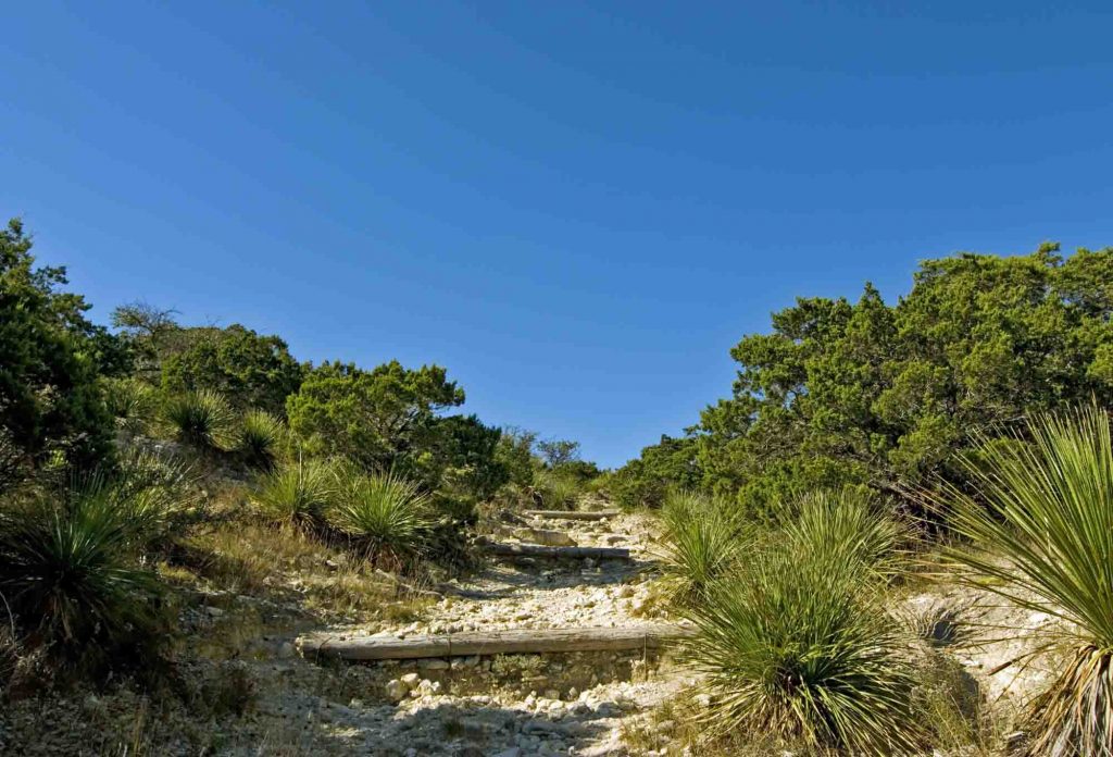
This short and sweet loop in Comanche Lookout Park (Nacogdoches Road) is suitable for all skill levels and super accessible from downtown San Antonio.
This is a great option if you’re just looking for some straightforward walking or a light workout. You can also bring along your furry friends as long as they’re on a leash.
However, like other popular hiking trails near San Antonio, this one can get rather busy during peak times, so plan ahead because parking is limited.
Braving the crowds is definitely worth it; hike all the way to the top, and you’ll be greeted by bird’s eye views of the city below.
Prairie, Painted Bunting, Barred Owl, and Live Oak Trails Loop

- Length: 5.1 miles | Elevation gain: 236.2 feet | Guide
For those that don’t love climbing and scrambling over rocky terrain, this loop swaps heart-pumping cardio for leisurely strolls through open meadows, prairies, and towering oak trees.
Of course, that means the Texas sun will be out in full force, so we suggest taking this trek in the morning or evening and stocking up on plenty of water and sunscreen whenever you go.
You’re almost guaranteed to spot some wildlife along the hike. Deer, hawks, armadillos, lizards, and snakes are commonly reported in the area.
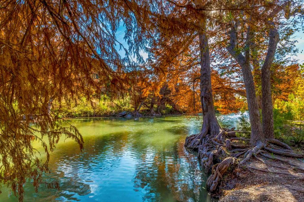
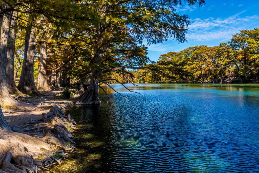
The nature in Guadalupe River State Park, where this trail resides, is some of the most rugged and beautiful in the state, and it’s only 45 minutes outside of San Antonio!
Bamberger Trail, Curry Creek Overlook Trail, and Golden-cheeked Warbler Loop

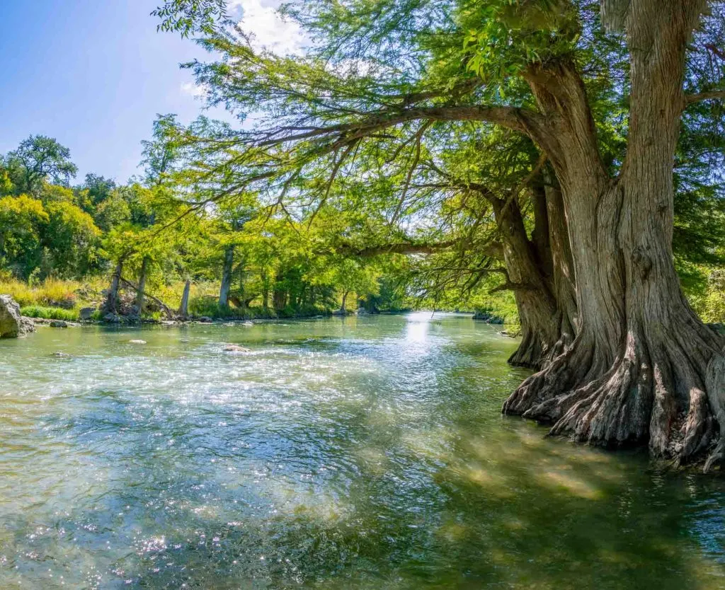
- Length: 3.5 miles | Elevation gain: 134.5 feet | Guide
This easy, wooded loop in Guadalupe River State Park is the Goldilocks of hiking trails–not too short, not too long, and with a wide range of both shaded and sunny spots.
Kids and dogs alike will manage the walk easily, while adults will enjoy the relaxing scenery.
The hike’s highlight is a section that runs alongside the oh-so-refreshing Guadalupe River, where you can wade in the clear, shallow water or rest on the rocks along the bank.
The area isn’t terribly busy, but mornings are still best if you want to hit the trails before they get a bit more crowded.
San Antonio Mission Trail
- Length: 15.1 miles | Elevation gain: 413.4 feet | Guide
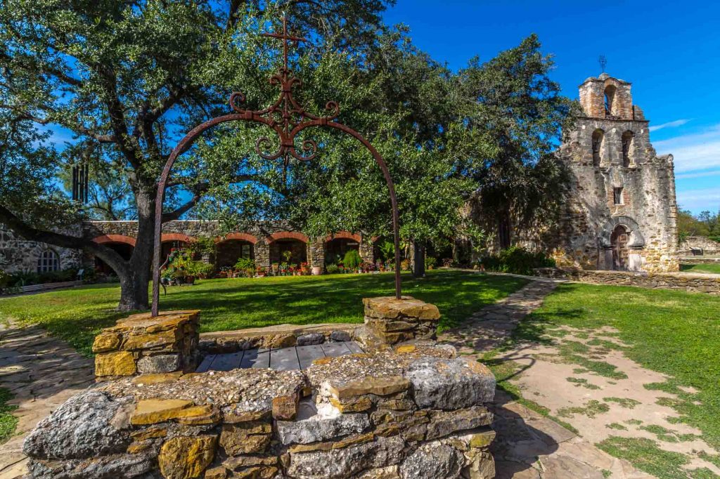
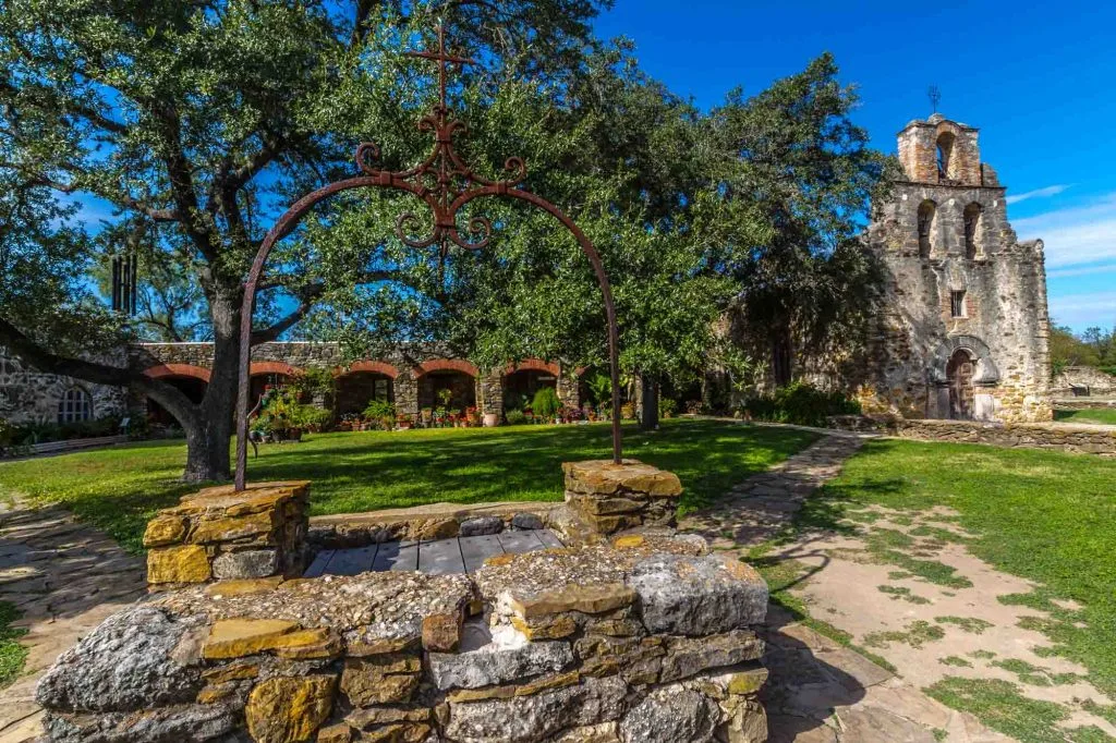
This wouldn’t be a post about hiking in San Antonio if we didn’t mention the iconic Mission Trail.
This is one of those San Antonio must-sees; it gets you up close and personal with one of only 16 national parks in Texas and the only UNESCO World Heritage Site in the state.
Explore the history and incredible architecture of four of the city’s Spanish colonial missions–Mission Concepcion, Mission San Jose, Mission San Juan Capistrano, and Mission Espada.
Each site is separated by about 2.5 miles of trail that wind through farmland, small neighborhoods, and city parks, with plenty of rest stops along the way so you can grab a bite to eat or refill your water.
Biking is an excellent option if walking the whole way seems a bit too time-consuming.
San Antonio River Walk Mission Reach Trail


- Length: 5.7 miles | Elevation gain: 141.1 feet | Guide
Multitaskers, this one’s for you! Anyone who wants to go hiking in San Antonio while sightseeing at the same time should definitely visit the River Walk Mission Reach Trail.
This is more of a leisurely walk than a true trek, but it’s the perfect way to explore lots of San Antonio on foot. The trail takes you through the heart of the city, with the option to stop at some of its top attractions as you go.
Check out the bold architecture of the historic Bexar County Courthouse, the ultra-artsy La Villita neighborhood, and (for extra walking fuel) some of the delicious restaurants that line the bank of the river.
Moderate San Antonio Hikes
Hillview Nature Trail Loop


- Length: 2.9 miles | Elevation gain: 282.2 feet | Guide
This moderately challenging hike is located in Eisenhower Park, just 25 minutes from downtown San Antonio, and offers a respite from the concrete trails found closer to the city center with its rocky terrain and steep climbs.
Some of the trek highlights are the wildflowers that color the hills every spring and an observatory that boasts a sprawling bird’s eye view over the trees.
Keep in mind that this is a popular hiking spot for locals and tourists alike, so the paths are often reasonably crowded.
To turn it into a full-day trip outside of downtown, stop by Six Flags Fiesta Texas on your way there or back; it’s right next door to the park.
Pssst: The Joe Johnston Route Trail in Government Canyon State Natural Area is a moderate but incredible hiking trail. Reservation needed.
Main Loop to Vista Loop to Fern Del Trail

- Length: 2.4 miles | Elevation gain: 360.9 feet | Guide
The Friedrich Wilderness Park is home to 10 miles of trails and some of the country’s best bird-watching.
This particular loop is one of the most beautiful places to hike in San Antonio, with drop-offs and dramatic canyons that offer spectacular views of the Hill Country.
It has a mix of terrain, with some spots that will definitely have you breathing hard and others that are great for all abilities.
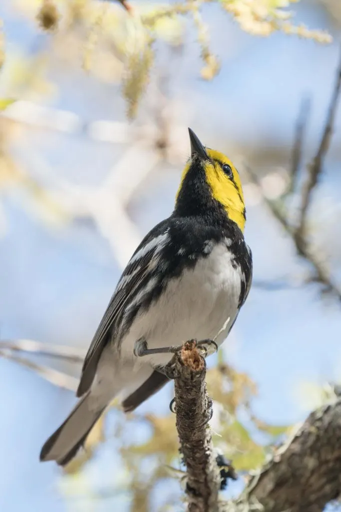
Keep an eye out for wildflowers and rare bird species like the Black-capped Vireo and the Golden-cheeked Warbler.
Some trails are closed during the rainier seasons, so check the weather conditions before you go.
Mount Ol’ Baldy

- Length: 1 mile | Elevation gain: 436.4 feet | Guide
If you want to move a bit beyond hiking in San Antonio itself and are hoping to see more of Texas Hill Country, Mount Ol’ Baldy is the place to be.
The drive from downtown to Garner State Park (one of the most beautiful state parks near San Antonio, especially for fall foliage—yes, there’s fall in Texas) takes 1.5-2 hours but offers scenic views of charming small towns and rolling hills along the way. Plus, it’s an excellent opportunity to rest your legs before and after the trek.
This out-and-back hike comes complete with rock scrambles to keep your adrenaline pumping and absolutely stunning panoramic views once you reach the top.
It’s doable for young children, but the whole family will definitely be sweating it out by the end.
Cougar Canyon to Hermit’s Trace Loop

- Length: 7.2 miles | Elevation gain: 669.3 feet | Guide
This loop in the gorgeous Hill Country State Natural Area is one of the lesser-known hikes near San Antonio, which means you’ll likely have the trail to yourself for most of the time.
To escape the crowds, you will have to drive about 1.5 hours outside of downtown, but there are places to camp in the park if you want to stay overnight.
The trail features a wide variety of terrains, everything from steep climbs and descents to flat, shady stretches. The views stretch all the way to the horizon as you climb, so you’ll truly feel immersed in the wilderness in this Texas hiking trail.
Keep an eye out for native plants and animals like deer, armadillos, and lots of wildflowers, as well as the horses that commonly carry riders along the route.
Your own animals are also allowed, as long as they’re on a leash.
Crystal Cave via Horseshoe Canyon and Bridges Trail Loop

- Length: 1.5 miles | Elevation gain: 403.5 feet | Guide
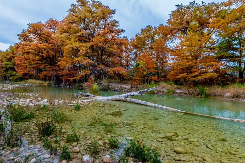
Garner State Park holds lots of gems, and this loop is just one of them. Hikers will love soaking in its panoramic views of the Hill Country’s rugged greenery and crystal clear rivers.
Parts of the trail can be challenging at times; there are sections with loose rocks and uphill scrambles. Overall, however, it’s a very family-friendly activity with an abundance of natural scenery.
The Painted Rock Overlook is breathtaking at sunset and Crystal Cave is a fun stop along the way. You can even climb through the cave and search for the bats that call it home–just don’t forget your flashlight!
McAllister Park Blue Loop Trail


- Length: 6.7 miles | Elevation gain: 236.2 feet | Guide
This popular loop is about 30 minutes outside of downtown but feels a world away.
You can likely get quite close to a friendly few deer and armadillos while you hike, and the massive Texas oaks and fields of wildflowers are well worth admiring.
If you’re traveling with a canine companion, you’re in luck. As though the trails weren’t enough to tire your pup out, McAllister Park also boasts a 1.5-acre, fenced dog park.
The Blue Loop Trail tends to be dominated by mountain bikers, so remember to be aware of your surroundings, especially while walking the narrower parts of the hike/bike trails.
There isn’t much shade on this walk, so it’s best not to hike during the summer months and to at least come prepared with lots of water.
Challenging San Antonio Trail
Flat Rock Ranch Mountain Biking Trails Loop


- Length: 25.8 miles | Elevation gain: 2135.83 feet | Guide
Welcome to the more extreme side of hiking in San Antonio. In fact, this spot is off limits for hikers and runners most of the year.
Boasting by far the most challenging terrain of any place on this list, the Flat Rock Ranch loop is designated primarily for serious mountain bikers, with special exceptions made for trail running events.
There are a few things you’ll want to keep in mind. First, there’s a $10 fee per person per day to use the Flat Rock Ranch trails, and the whole route is closed for hunting season every October-December.
With jumps, steep downhills, and rocky slopes, the riding here can get quite technical, so only go if you’re confident in your abilities.
Which of the best hikes in San Antonio are you most excited to tackle? Drop us a comment!